
A lidar drone survey is a powerful way to map the world in three dimensions. The simplest way to think about it is like a bat's echolocation, but instead of sound waves, it uses millions of laser pulses to measure distances with incredible precision. This gives industries the ability to see things a normal camera would miss, like the true ground level beneath a dense forest canopy.
What a LiDAR Drone Survey Reveals

If you've ever tried to map a complex asset like a powerline corridor or a thick forest with a camera, you know the frustration. You only capture the surface—a blanket of green leaves or the general shape of the wires. You’re completely blind to what's happening underneath. For industries like utilities, mining, and transportation, this information gap is a significant industrial pain point that leads to major inefficiencies and hidden safety risks.
A lidar drone survey completely solves this problem. A LiDAR sensor sends out thousands of laser pulses every second, and many of those pulses find their way through gaps in vegetation. The sensor captures multiple "returns" from each pulse, mapping not just the treetops, but the branches, undergrowth, and, crucially, the actual ground hiding below.
From Slow and Dangerous to Fast and Accurate
For years, getting this kind of detail meant putting boots on the ground. Traditional survey crews are slow, expensive, and often have to work in hazardous conditions, from steep, unstable slopes to active mine sites. A LiDAR drone can turn weeks of dangerous manual labor into just a few hours of safe, automated flight.
- Speed: A drone can cover hundreds of acres in a single day, a job that might take a ground crew weeks to complete.
- Safety: You can keep your team out of harm's way, avoiding active roadways, unstable terrain, or high-voltage zones.
- Accuracy: LiDAR delivers survey-grade precision, capturing data with millimeter-level detail that’s impossible to get at scale by hand.
This isn't just a small step forward; it's a completely new way of operating. The demand for this capability is surging, with the global LiDAR drone market growing from USD 129.0 million in 2020 to a projected USD 455.0 million by 2028. You can review the full market analysis to see what's driving this incredible growth.
Before we dive deeper, let's look at how LiDAR drone surveying stacks up against the methods it's rapidly replacing.
LiDAR Drone Surveying vs Traditional Methods
| Attribute | LiDAR Drone Survey | Traditional Ground Survey | Aerial Photogrammetry |
|---|---|---|---|
| Data Type | 3D point cloud (direct measurement) | Individual 3D points (manual) | 2D images processed into 3D models |
| Vegetation Penetration | Excellent; can "see" through canopy to the ground | Very good, but slow and point-by-point | Poor; captures the top of the canopy only |
| Speed & Coverage | Very fast; hundreds of acres per day | Extremely slow; point-by-point collection | Fast; thousands of acres per day |
| Accuracy | High (centimeter to millimeter-level) | Very high (millimeter-level), but localized | Good, but less accurate than LiDAR, especially for Z-axis |
| Safety | High; remote operation keeps personnel safe | Low; exposes crews to site hazards | High; remote operation |
| Cost | Moderate initial investment, low operational cost | High labor costs for large areas | Low to moderate hardware cost |
As you can see, LiDAR drones hit a sweet spot, combining the speed of aerial methods with accuracy that rivals ground-based work, all while keeping crews safe.
A LiDAR drone survey gives you more than just a map—it provides "x-ray vision" for your assets and terrain. It's about getting the ground truth you need to make faster, smarter decisions that simply weren't possible before.
Unlocking New Operational Insights
This technology allows you to move beyond simple mapping and start doing predictive analysis. For an electric utility, the constant worry is vegetation growing too close to powerlines and causing outages. The industrial pain point here is the reactive, inefficient nature of traditional vegetation management. Using a high-density LiDAR sensor on a drone like the Evolution Flight, you can create a perfect digital twin of your entire powerline corridor.
This highly detailed model shows exactly where a tree branch is getting too close, allowing you to dispatch a crew for proactive trimming before it causes a failure. This is how a lidar drone survey transforms raw data into a real competitive advantage, helping you reduce risk, cut operational costs, and gain a whole new level of situational awareness.
How a LiDAR Drone Sees the World
To really get what makes a lidar drone survey so powerful, you have to understand how the technology actually works. It’s a beautifully simple concept that turns rapid-fire laser pulses into an incredibly precise 3D map of the ground below.
Imagine the drone is essentially firing a constant stream of tiny, invisible darts at the speed of light. A LiDAR sensor, at its heart, is a laser scanner that emits up to hundreds of thousands of these light pulses every single second. As the drone flies, it blankets the entire area—trees, buildings, power lines, and all—in a dense grid of laser points.
The Journey of a Single Laser Pulse
Each one of those pulses travels down from the drone until it hits something. It might be the top of a tree, a utility wire, the roof of a building, or the bare earth.
Once a pulse hits an object, it reflects back up to the sensor on the drone. Now, here’s the clever part. A single pulse can bounce off multiple things on its way down. For example, it might hit a leaf at the very top of a tree (the first return), pass through and hit a lower branch (a middle return), and finally hit the ground itself (the last return).
The sensor then receives each of these returning signals. Onboard the drone, an incredibly precise timer and an Inertial Measurement Unit (IMU) work together. They log the exact time it took for that pulse to leave the drone, hit something, and come back.
By measuring this round-trip time, the system calculates the distance to the object with exceptional accuracy. When you multiply this process by millions of data points, you build a dense, information-rich "point cloud" that represents the real world in stunning 3D detail.
Turning Technical Specs into Business Outcomes
This isn't just a neat bit of engineering; it's a direct solution to some very expensive and dangerous problems. Take one of the biggest headaches for electric utilities: vegetation getting too close to power lines. The industrial pain point is the inability to get accurate, timely data on these clearance distances, leading to catastrophic wildfire risk or massive blackout events.
Sending crews out to walk the lines is slow, dangerous, and they often miss problems. A regular camera drone can't tell you the exact distance between a branch and a wire. This is where the specific design of a modern LiDAR system proves its worth. A platform like the Evolution Flight Falcon is designed with the technical specification of high-lift capacity, allowing it to carry advanced LiDAR sensors. These sensors feature:
- High Pulse Repetition Rate: Firing more pulses per second creates a higher point density, meaning a more detailed and accurate final model.
- Multiple Returns: The ability to capture multiple returns from a single pulse is what lets the sensor "see" through a tree canopy to map the outer leaves, the inner branches, and—most importantly—the power lines and ground hidden beneath.
For a utility manager, that high point density and multiple returns are not just specs; they deliver a critical business outcome: a true "digital twin" of the entire power corridor. With this model, you can measure the exact distance—down to the centimeter—between any tree and any wire. You stop reacting to outages and start preventing them with targeted, efficient trimming. It turns infrastructure management from a guessing game into a data-driven science, which ultimately makes the grid safer and more reliable for everyone.
Your End-to-End LiDAR Drone Survey Workflow
Thinking that a professional LiDAR survey is just about flying a drone is a common mistake. In reality, a successful mission is a carefully orchestrated process, where every stage—from planning on paper to delivering actionable data—builds on the last. Getting it right means turning raw laser pulses into a powerful tool for business decisions.
The value of getting this process right is clearer than ever. The global LiDAR drone market, valued at USD 240.7 million in 2025, is projected to soar to USD 763.2 million by 2034. This isn't just a fleeting trend; it reflects a fundamental shift in how industries get the precise 3D data they need. You can see the full analysis in this report on LiDAR drone market growth.
Let's break down the entire workflow, from start to finish.
Stage 1: Mission Planning and Platform Selection
Everything starts with a single question: What problem are you trying to solve? Before a drone's propellers even spin up, you need a crystal-clear objective. Are you checking for vegetation growing too close to power lines? Calculating stockpile volumes at a quarry? Or mapping a new railway corridor? Your answer will shape every decision that follows.
This is where you tackle real-world business challenges head-on. Imagine a mining company that needs to survey a massive, active pit. The core industrial pain point isn't just mapping the area; it's the massive cost of operational downtime required for a traditional survey. Shutting down operations for even a few hours is incredibly expensive.
This operational constraint points you directly to the right equipment. You can't use a standard drone that needs a battery swap every 20 minutes. You need a workhorse.
This is exactly the kind of scenario where a heavy-lift platform like the Evolution Flight Falcon shines. Its extended flight time is a key technical specification that delivers a critical business outcome: By eliminating the need for multiple battery swaps, it dramatically reduces operational downtime, allowing a survey team to cover more ground in a single flight and get off-site faster.
Stage 2: Data Capture in the Field
With a solid plan and the right gear, it's time to head out to the field. The data capture phase is where the plan meets reality. It's more than just hitting "launch"—it’s about executing the flight with precision to ensure you get the best possible raw data.
A few non-negotiables for high-quality data capture include:
- Ground Control: Always set Ground Control Points (GCPs). These are points on the ground with precisely known coordinates. They act as anchors for your data, allowing you to lock your point cloud into a real-world coordinate system with survey-grade accuracy.
- Flight Parameters: Your flight altitude, speed, and the overlap between flight lines are critical. Flying lower and slower with more overlap gives you a denser, more accurate point cloud, but it also takes more time. The trick is finding the right balance for your specific project goal.
- System Calibration: Before every flight, run a quick calibration maneuver, usually a figure-eight pattern. This simple step ensures the Inertial Measurement Unit (IMU) inside the LiDAR system is properly oriented, which is fundamental for accurate data.
The goal here is simple: capture clean, complete data the first time. Re-flights are expensive and throw schedules into chaos.
This diagram shows what's happening inside the sensor during the flight.
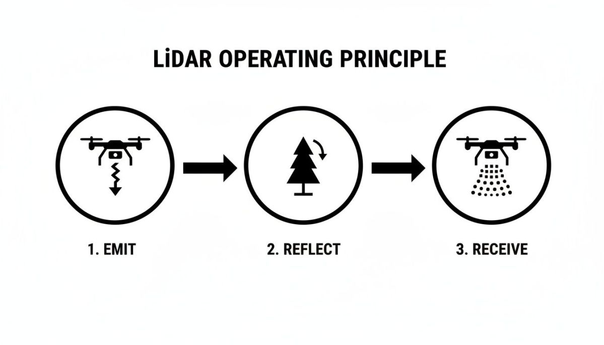
The sensor repeats this simple "ping and listen" process millions of times per second, building an incredibly detailed 3D picture of the world below.
Stage 3: Processing and Delivering Actionable Insights
Once the drone is back on the ground, the work moves to the office. This is where the millions of raw data points are processed, cleaned, and transformed into something genuinely useful. Honestly, this post-processing stage is often the most complex and time-consuming part of the entire LiDAR drone survey.
The main steps look something like this:
- Point Cloud Generation: The raw sensor data is merged with the drone's navigation data (GPS and IMU) to generate the initial, georeferenced point cloud.
- Data Cleaning and Filtering: Using a mix of automated tools and manual review, you'll remove "noise" from the data. This could be anything from a bird flying through the scan to atmospheric interference that created stray points.
- Point Cloud Classification: This is the magic. Sophisticated algorithms automatically classify points into logical categories—like ground, vegetation, buildings, or power lines. This step is what allows you to separate the bare earth from the features sitting on top of it.
- Deliverable Creation: With a clean, classified point cloud, you can finally create the specific products the client needs.
These final products are the entire point of the survey. The table below shows some of the most common deliverables and how they are used across different industries.
Common LiDAR Data Deliverables and Their Applications
| Deliverable | Description | Primary Industry Use Case |
|---|---|---|
| Classified Point Cloud (.las/.laz) | The raw 3D data with each point categorized (e.g., ground, vegetation, building). | Utilities: Detailed vegetation encroachment analysis near power lines. |
| Digital Elevation Model (DEM) | A 3D model representing the bare-earth surface, with all vegetation and structures removed. | Emergency Response: Floodplain mapping and landslide risk assessment. |
| Digital Surface Model (DSM) | A 3D model that includes the tops of all features, like tree canopies and building roofs. | Telecommunications: Line-of-sight analysis for new cell tower placement. |
| 3D Mesh / Model (.obj, .fbx) | A photorealistic or wireframe 3D model of a specific asset or area. | Construction: As-built verification against design plans. |
| Contour Lines (.dwg, .shp) | Traditional 2D lines that connect points of equal elevation, used in topographic maps. | Civil Engineering: Site planning and earthwork volume calculations. |
| Canopy Height Model (CHM) | A model showing the height of vegetation by subtracting the DEM from the DSM. | Forestry: Assessing timber volume and forest health. |
Ultimately, following this end-to-end workflow turns a highly technical process into a repeatable, reliable source of business intelligence. It’s how you ensure every flight delivers tangible, valuable results.
Real-World Applications Solving Industry Problems

The theory behind a lidar drone survey is interesting, but its real power is in solving expensive, nagging, and often dangerous problems on the ground. This is where the abstract idea of a point cloud becomes a tool that generates real-world returns for businesses. We're seeing this shift happen quickly.
The drone segment of the LiDAR mapping market was valued at USD 1.3 billion in 2025, and it's projected to grow at a blistering 27.7% each year through 2035. Why? Because drones can get into difficult-to-reach places far more efficiently than any other method, which is a game-changer for industries like mining and utilities. You can find more details on LiDAR's rapid market expansion and how it’s changing operations.
Electric Utilities Preventing Costly Outages
For electric utilities, the constant headache is vegetation encroachment. The primary industrial pain point is the risk of a tree branch falling on a power line, triggering a massive outage, repair bills, regulatory fines, and serious public safety risks. Having crews walk thousands of miles of transmission corridors is slow, they miss things, and it puts them in hazardous situations.
This is a perfect scenario for a LiDAR drone.
- A lidar drone survey quickly builds a high-fidelity 3D "digital twin" of the entire power line corridor.
- This incredibly dense point cloud maps the precise location of every single wire, pole, and branch.
- With that data, utility managers can run automated clearance checks, pinpointing the exact spots where trees are getting too close to the lines.
Suddenly, they can move from reacting to outages to proactively trimming vegetation where it’s needed most. The result is a more reliable grid and a massive reduction in the risk of a catastrophic failure.
Mining Operations Improving Financial Forecasting
In mining, your profitability is directly tied to knowing exactly how much material you've dug up and moved. But measuring massive, constantly changing stockpiles is a huge challenge. Traditional survey methods are slow, they put surveyors in the path of heavy machinery, and the numbers are often just estimates.
A major industrial pain point for mine operators is the financial uncertainty that comes from fuzzy inventory numbers. If you don't know exactly what you have in your stockpiles, your production reports are flawed and your financial forecasts are unreliable.
This is where a purpose-built aerial platform shines. The Evolution Flight Falcon, for instance, has the technical specification of heavy-lift capacity, allowing it to carry a high-end LiDAR sensor over large areas. The business outcome is that instead of relying on guesswork, mine operators get fast, repeatable, and incredibly accurate volume calculations. This leads to tighter inventory control, more dependable financial reporting, and smarter decisions on the ground.
Transportation Agencies Accelerating Project Timelines
Think about the monumental task of planning a new highway or railway. The very first step—route planning and design—requires incredibly detailed topographic maps across long, linear corridors. Sending survey crews out on foot is painstakingly slow and expensive, often taking months and holding up the entire project.
- The industrial pain point: Traditional corridor mapping is a major bottleneck, delaying critical infrastructure projects from the start.
- The LiDAR solution: A lidar drone survey can map an entire proposed route in just a few days, capturing detailed bare-earth topography even through dense forest canopies.
- The business outcome: Engineers get the accurate terrain models they need in a fraction of the time. This dramatically speeds up the design and approval process, which saves taxpayer money and gets essential projects moving much faster.
Calculating the ROI of Your LiDAR Drone Program
Sooner or later, every enterprise leader asks the same question: what’s the return on this investment? A lidar drone survey program is a serious investment, that’s for sure. But focusing only on what it costs compared to traditional surveys misses the bigger picture. The real payback comes from preventing disasters, finding new efficiencies, and making work safer for your team.
Thinking about ROI means looking at what you spend and what you gain. The upfront costs are easy to spot—hardware, specialized software, and getting your team trained up. The gains, however, come in two flavors: the money you save directly and, more importantly, the massive costs you manage to avoid entirely.
Quantifying the Tangible Returns
The direct savings are the most straightforward. Just compare the cost of running a survey with your own drone team against hiring it out or using a traditional ground crew. It’s not uncommon for a drone team to wrap up a project in a day that would take a ground crew weeks. Those savings on labor and mobilization alone can be huge.
But the most powerful financial impacts aren't from the money you save, but from the problems you prevent.
- Risk Mitigation: For a utility, preventing a single wildfire sparked by a sagging power line can literally save millions in fines, lawsuits, and repairs. That one event can pay for the entire program, many times over.
- Operational Efficiency: Think about a mine that has to shut down a haul road for a survey. Slashing that survey time from a week to a few hours means more time hauling, processing, and generating revenue.
- Enhanced Safety: Every time you can survey an active highway, a steep slope, or a restricted area without putting a person there, you’re winning. You reduce the risk of a workplace injury and all the immense direct and indirect costs that come with it.
A Utility Company ROI Scenario
Let's walk through a real-world example. Imagine an electric utility that manages thousands of miles of power lines. Their biggest industrial pain point is vegetation encroachment—trees and branches growing too close to the lines, which is a primary cause of outages and wildfires. Sending crews to walk these lines is painstakingly slow, expensive, and often dangerous.
So, the utility decides to bring this work in-house. They invest in a drone program built around the Evolution Flight Falcon, a drone they picked specifically for its technical specification of heavy-lift capacity. This isn't just a technical detail; it's what allows them to fly a high-end, survey-grade LiDAR sensor.
The business outcome is a night-and-day difference in data quality and speed. The powerful sensor captures an incredibly dense point cloud, letting them measure the distance between a tree branch and a power line down to the centimeter. With that level of precision, they can stop blanketing entire regions with trimming crews and start a targeted, proactive maintenance plan.
Yes, the initial investment in the drone, sensor, and training was significant. But in this scenario, the program pays for itself within the first year by preventing just one major outage. After that, the compounding savings from smarter maintenance, lower crew risk, and a more reliable grid deliver a continuous return year after year. The lidar drone survey program stops being a cost center and becomes a core strategic advantage.
How to Choose the Right LiDAR Drone Partner
Picking a partner for your lidar drone survey program is a lot like choosing any other critical piece of equipment. You're not just buying a tool; you're investing in a capability. It can be tempting to focus on the upfront cost, but the cheapest drone often becomes the most expensive problem down the line.
A true partner delivers a complete solution, not just a drone in a box. They’ve been in the trenches, they understand your industry's headaches, and they provide the right hardware, seamless integration, and expert support to actually get the job done. Without that complete package, a sophisticated drone quickly becomes a high-tech paperweight.
Look Beyond the Drone to the Entire Solution
For teams in defense, government, and critical infrastructure, the conversation goes even deeper. The real industrial pain point isn't just about getting accurate data—it's about protecting the security and integrity of that data from the moment it's captured. A low-cost drone from an unvetted source can introduce massive supply chain risks, potentially exposing sensitive information about national assets.
This is where a partner’s commitment to security becomes a deal-breaker. You need to see tangible proof. For instance, Evolution Flight's pursuit of Green UAS certification and its strict adherence to NDAA compliance are technical specifications that directly address the serious problem of data security.
These certifications provide the crucial business outcome of a secure, verified supply chain. They give you confidence that your platform is free from malicious hardware or software, protecting your mission-critical data and ensuring your operations align with national security standards.
Matching Capabilities to Your Industry's Needs
Enterprise-level drone programs are never one-size-fits-all. Your ideal partner acts more like a consultant, digging into your specific operational challenges to help you build a system that’s perfectly suited for your mission.
A utility company, for example, faces the industrial pain point of needing absolute reliability for mapping long, uninterrupted corridors of power lines. This requires a platform with very specific characteristics. The Evolution Flight Falcon was engineered with a technical specification of heavy-lift capacity, allowing it to carry the high-end, survey-grade LiDAR sensors needed for the job.
This powerful combination delivers the business outcome of capturing the incredibly dense and accurate data required for precise vegetation analysis, which directly helps you maintain a safer, more reliable grid. Finding a partner who delivers this kind of tailored capability is what sets a lidar drone survey program up for real, long-term success.
Frequently Asked Questions About LiDAR Drone Surveys
When teams like yours start looking into adding a lidar drone survey program, the same great questions always come up. Here are some straightforward answers to help you get a clear picture of what's involved.
How Does LiDAR Compare to Photogrammetry?
This is easily the most common question we hear. Think of it as a choice between two excellent, but different, tools. Photogrammetry, which stitches together thousands of photos to build a 3D model, is fantastic for many jobs. The problem is, it can't see what it can't photograph.
That means dense tree canopies, thick brush, or even just shadows can create huge gaps or inaccuracies in your data. It also tends to struggle with visually uniform surfaces like large asphalt lots or snow-covered fields.
LiDAR, on the other hand, shines exactly where photogrammetry falls short. Its laser pulses punch right through vegetation to map the true ground surface underneath. For any project involving vegetation, complex infrastructure, or corridor mapping, LiDAR delivers a much more complete and trustworthy set of data.
What Accuracy Can I Expect From a LiDAR Survey?
With a quality sensor, a stable drone, and solid fieldwork, you can consistently achieve survey-grade accuracy of 1-5 centimeters. This isn't just a number on a spec sheet; it's the level of precision required for high-stakes work like construction verification, creating as-built models for digital twins, and performing detailed asset management.
A huge industrial pain point for infrastructure operators is getting data they can actually trust for engineering and design. This is where your choice of drone really matters. For instance, a platform like the Evolution Flight Falcon has the technical specification of heavy-lift capacity, which is required to carry a high-end, survey-grade LiDAR sensor. That capability delivers the business outcome of capturing data that is dense and accurate enough to meet those strict precision standards.
Of course, the technology is only part of the equation. Hitting that top-tier accuracy depends just as much on the human element. It takes proper mission planning, the smart use of ground control points, and careful post-processing to get a final result you can bank on.
How Difficult Is It to Get Started?
There’s a learning curve, no doubt, but getting a LiDAR program off the ground is more straightforward than ever. In the past, the sheer cost and complexity meant this was a job for highly specialized technicians. Today, integrated drone and sensor packages have simplified the entire workflow from start to finish.
The goal isn't to make you go out and hire a whole new team of LiDAR gurus. A good partner will provide the training and support to get your existing survey and inspection crews up to speed. With the right hands-on guidance, they can add this powerful tool to their skillset and become even more effective in the field.
At Evolution Flight, we provide the robust platforms and expert guidance you need to build a successful in-house LiDAR program. Discover the right solution for your mission by exploring our advanced UAS platforms.